
Showing posts with label Aboriginal People. Show all posts
Showing posts with label Aboriginal People. Show all posts
Tuesday, September 25, 2012
Thursday, November 17, 2011
Mental blank.
Tonight when I sat down to type this post I couldn’t think of a single thing to post about.
I seem to be using up my creative energy on my WIP and on photography at the moment.
Ah well I’ll just have to rely on the second of those for a post tonight.
Back to the Grampians tonight.
During our second day there we visited a second Aboriginal rock art site.
Like Billimina this site is also protected behind a wire barrier.
The mindless morons who vandalized this panel of figures show why the protection is needed. This panel has a faint parade of figures across it.
  I wonder if they represent the people who lived here or spirits.
Finally two sections that give the shelter its name Manja, Manja means ‘hands’ in the language of the people of this land.
This last photo is one of my favorite ever. Technically it isn’t a great photo but I really feel it captures the essence of this place. It feels to me that the people of old have reached down through the centuries to touch us today.
I seem to be using up my creative energy on my WIP and on photography at the moment.
Ah well I’ll just have to rely on the second of those for a post tonight.
Back to the Grampians tonight.
During our second day there we visited a second Aboriginal rock art site.
Like Billimina this site is also protected behind a wire barrier.
The mindless morons who vandalized this panel of figures show why the protection is needed.
 This panel has a faint parade of figures across it.
 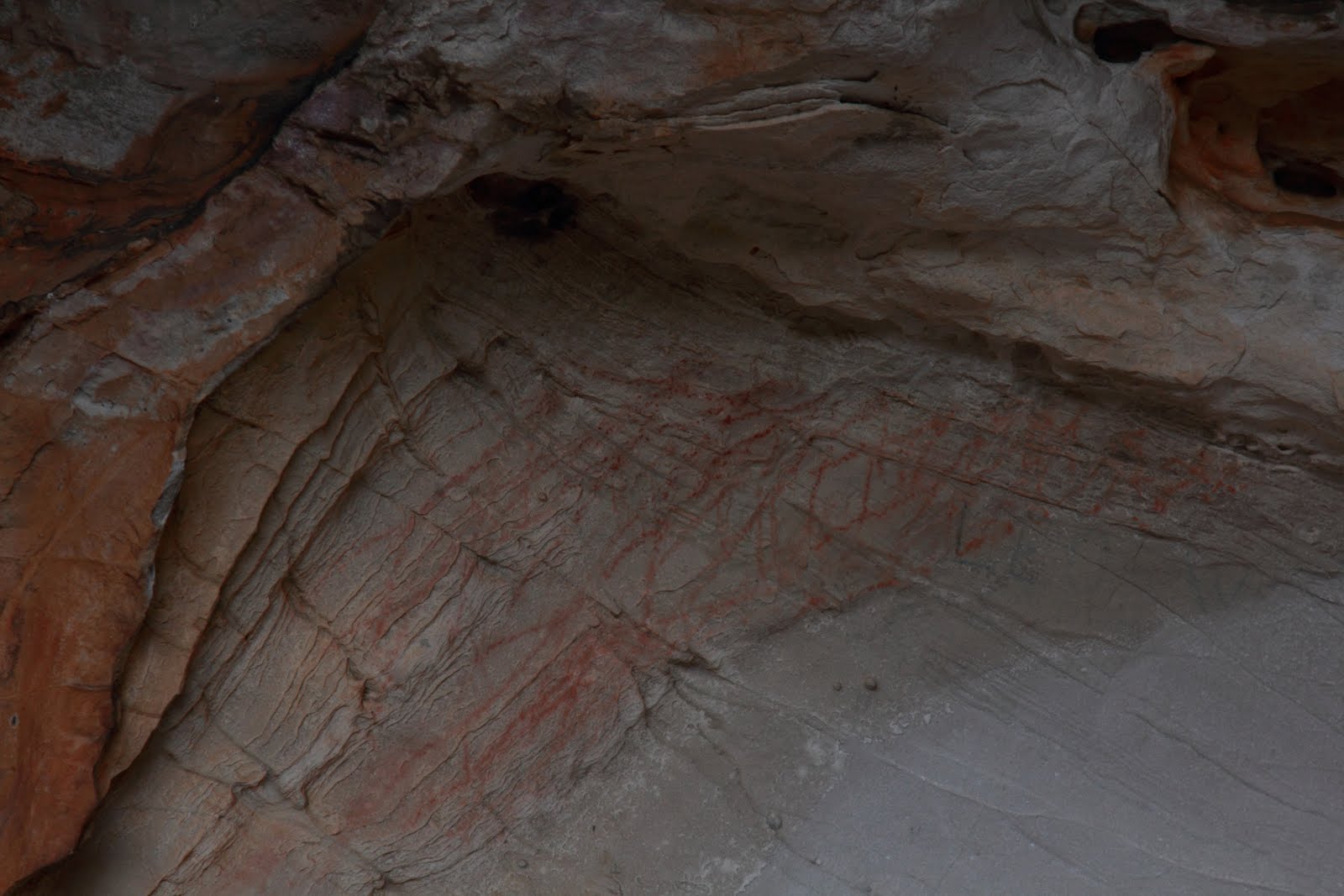 I wonder if they represent the people who lived here or spirits.
Finally two sections that give the shelter its name Manja,
 Manja means ‘hands’ in the language of the people of this land.
This last photo is one of my favorite ever.
Technically it isn’t a great photo but I really feel it captures the essence of this place. It feels to me that the people of old have reached down through the centuries to touch us today.
Tuesday, September 6, 2011
In which Al answers questions
A couple of questions were asked about my recent posts so I thought I would attempt to answer them. When I posted about these Aboriginal hand prints at the Grampians, Kathleen Jones asked about the images “Do you suppose it was some kind of 'coming of age' ritual?”
Well that is hard to say, only the people who made the marks could say for sure. Aboriginal people had many levels of knowledge; some of which were available to anyone and others which could only be revealed to people initiated in the right way.
I remember meeting Aboriginal elders in northern NSW who talked about much of the ‘dreaming’ of their people which had been lost. It was lost because their parents and grandparents had refused to pass it on to even their own relatives because they had not been properly initiated in the old ways.
However given that the hand prints were all of young people ‘coming of age’ was probably part of the story. But it was most likely more complex, the platform the shelter sits above has an amazing view far out into the northern plains. Any ceremony here was likely to have been about the ‘country’ that the young people belonged to as much as about them.
Now a little more ‘down to earth’
Susan Flett Swiderski asked of my last post “I take it you have a LOT of waterfalls in your area?” This is a question that is also a little complex. The simplest way to put it is that depends on your frame of reference.
Victoria, the state I live in, is Australia’s second smallest. It is about the size of Minnesota in the USA or about the same size as the United Kingdom
The waterfalls I have posted in the past few months are in an area 473km (295 miles) across. To a Victorian that seems like a huge space but to a Queenslander like me it seems a relatively short distance. Queensland our second largest state is bigger than Alaska (or in European terms bigger than France, Germany, Spain and Italy put together).
Now as a reward for making you sit through all that some piccies of Trentham Falls that I took on Sunday. I spent a couple of hours shooting the falls from many angles.
  From almost level with the top of the 82 metre (270 ft) falls
 to the river bed at the base.
 That was quite a climb on the way back up!
When I posted about these Aboriginal hand prints at the Grampians, Kathleen Jones asked about the images “Do you suppose it was some kind of 'coming of age' ritual?”Well that is hard to say, only the people who made the marks could say for sure. Aboriginal people had many levels of knowledge; some of which were available to anyone and others which could only be revealed to people initiated in the right way.
I remember meeting Aboriginal elders in northern NSW who talked about much of the ‘dreaming’ of their people which had been lost. It was lost because their parents and grandparents had refused to pass it on to even their own relatives because they had not been properly initiated in the old ways.
However given that the hand prints were all of young people ‘coming of age’ was probably part of the story. But it was most likely more complex, the platform the shelter sits above has an amazing view far out into the northern plains.
 Any ceremony here was likely to have been about the ‘country’ that the young people belonged to as much as about them.
Now a little more ‘down to earth’
Susan Flett Swiderski asked of my last post “I take it you have a LOT of waterfalls in your area?”
This is a question that is also a little complex. The simplest way to put it is that depends on your frame of reference.Victoria, the state I live in, is Australia’s second smallest. It is about the size of Minnesota in the USA or about the same size as the United Kingdom
The waterfalls I have posted in the past few months are in an area 473km (295 miles) across. To a Victorian that seems like a huge space but to a Queenslander like me it seems a relatively short distance. Queensland our second largest state is bigger than Alaska (or in European terms bigger than France, Germany, Spain and Italy put together).
Now as a reward for making you sit through all that some piccies of Trentham Falls that I took on Sunday.
 I spent a couple of hours shooting the falls from many angles.
  From almost level with the top of the 82 metre (270 ft) falls
 to the river bed at the base.
 That was quite a climb on the way back up!
Thursday, September 1, 2011
Young People
I can’t believe it was Saturday I posted last.
It has been a mad week at work. I seem to be home late almost every night and hit the sack soon after.
Still even long days give me a couple of hours to work on my WIP. I have read it all through a couple of times an am still shuffling sections around and writing bits and pieces to link those sections.
So I guess I’ve sort of begun working on a second draft, but it really doesn’t feel like it.
Now for something different I’m going to share some more piccies from our second day at the Grampians.
In the afternoon we headed towards another spot about ten kilometers (6 miles) from the Ngamdjidj rock shelter.
It was still fairly early so I paused to photograph these odd flower buds


High on the flanks of the hill under a rock ledge very like this

is the Gulgurn Manja Aboriginal rock shelter.
In the shelter is more rock art.
Pictures of emu footprints

Seemingly abstract symbols

And what I think makes this place most special.

For Gulgurn Manja means “hands of the young people” in the local Aboriginal language.
The rock surface is covered with hand prints made by children between the ages of 8 and 12 over many generations.

It is like these young people have left part of themselves in the landscape.

I found it very magical.
Thursday, August 18, 2011
Grampians Part II
I woke early on Sunday. Leaving Deb asleep in the motel I went out for a stroll to see if I could catch some shots of dawn in Halls Gap.
It was a frosty morning (remember it is winter down this way) The local wildlife brave coming down into the town before people stir.
These are eastern grey kangaroos.
I was able to get quite close. It has been a good season so the kangaroos are busy raising their young. Being marsupials they carry their young around in pouches.
Cute aren’t they? After breakfast we headed out for a day in the northern Grampians.
 I paused frequently to catch shots of the ranges.
At one spot I caught this little wildflower. Along this bush road we came to the foot hills of Mount Zero
 I paused to catch more wildflowers.
 All around the Grampians Heath Myrtle was flowering
 A close up.
  Further along the road we reach our destination for the morning,
 The Ngamdjidj Rock Shelter
  on the walls ancient Aboriginal paintings
It was a frosty morning (remember it is winter down this way)
 The local wildlife brave coming down into the town before people stir.
These are eastern grey kangaroos.
I was able to get quite close. It has been a good season so the kangaroos are busy raising their young.
 Being marsupials they carry their young around in pouches.
Cute aren’t they?
 After breakfast we headed out for a day in the northern Grampians.
 I paused frequently to catch shots of the ranges.
At one spot I caught this little wildflower.
 Along this bush road we came to the foot hills of Mount Zero
 I paused to catch more wildflowers.
 All around the Grampians Heath Myrtle was flowering
 A close up.
  Further along the road we reach our destination for the morning,
 The Ngamdjidj Rock Shelter
  on the walls ancient Aboriginal paintings
Friday, April 16, 2010
The Present and the Past
Behind the Bridgewater Lakes (where we had an enjoyable lunch) is a limestone ridge riddled with caves.


These caves are collectively called the Tarragal Caves.
When we were there I didn’t know anything about them, but they were close to the road so I just had to climb up and have a look.
As I climbed the slope to the cave mouths I watched the ground closely. As I went I began to notice fragments of shell scattered through the grass.
Back in my university days I spent a few field seasons on some Archaeology digs and surveys. I have vivid memories of spending a full month helping a friend sort ancient fish bone and shells from a coastal Aboriginal midden (rubbish heap) as she gathered data for her thesis. It was simultaneously fascinating and ridiculously tedious, but I learnt a lot about coastal archaeology in the process.
The shell material I saw scattered down the slope was very reminiscent of that midden, and others I have seen. So as I climbed the slope to those caves I was fairly sure they had been used by Aboriginal people as rock shelters.
The largest cave had a sandy floor in one corner. This sand was also littered with tiny shell fragments.
 My impression of long term use was further concreted by what appears to be heavy smoke staining, possibly from hundreds of years of camp fires.
 One corner of the large cave held this large pillar formed when a stalactite and stalagmite joined.
 At the far end of the complex is a lower, but deeper cave.
 It also has a sandy floor this time with very recognisable shells and pieces of charcoal.
 This piccie is taken looking out of the smaller cave.
  The car parked near the junction is ours, Deb was no doubt knitting as she waited for me.
The view from the cave mouth, it is easy to see why the local people chose to use this spot. Quite apart from the nearby marine resources and the shelter, it is simply beautiful.
 As we drove away I commented to Deb that I would have to find out if there was any information on prehistoric use of the caves.
Well I found a little, records I could access indicated that the caves were in use.
Also there was an Aboriginal myth associated with the cave. They apparently believed their creator spirit Bundjil sometimes lived in one of the caves and also descended from there to “walk the shore”.
Then I found this an engraving made by Thomas Ham, a surveyor in 1851
 Thomas took some licence with the background but the basic shape is right when looking out of the cave, in particular the pillar on the right is very recognisable. Also if you compare it with my piccie of the view the basic propertions of the cape in the distance are more or less right.
I wonder if there were Aboriginal people there when Thomas Ham visited? Or were they added to the sketch for “colour”?
The British visitors with their early Victorian period formal attire crack me up. How different was my attire, jeans and t-shirt!


When we were there I didn’t know anything about them, but they were close to the road so I just had to climb up and have a look.
As I climbed the slope to the cave mouths I watched the ground closely. As I went I began to notice fragments of shell scattered through the grass.

Back in my university days I spent a few field seasons on some Archaeology digs and surveys. I have vivid memories of spending a full month helping a friend sort ancient fish bone and shells from a coastal Aboriginal midden (rubbish heap) as she gathered data for her thesis. It was simultaneously fascinating and ridiculously tedious, but I learnt a lot about coastal archaeology in the process.
The shell material I saw scattered down the slope was very reminiscent of that midden, and others I have seen. So as I climbed the slope to those caves I was fairly sure they had been used by Aboriginal people as rock shelters.
The largest cave
 had a sandy floor in one corner. This sand was also littered with tiny shell fragments.
 My impression of long term use was further concreted by what appears to be heavy smoke staining, possibly from hundreds of years of camp fires.
 One corner of the large cave held this large pillar formed when a stalactite and stalagmite joined.
 At the far end of the complex is a lower, but deeper cave.
 It also has a sandy floor this time with very recognisable shells and pieces of charcoal.
 This piccie is taken looking out of the smaller cave.
 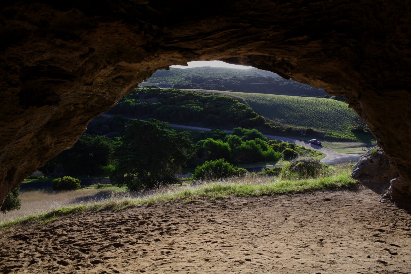 The car parked near the junction is ours, Deb was no doubt knitting as she waited for me.
The view from the cave mouth, it is easy to see why the local people chose to use this spot. Quite apart from the nearby marine resources and the shelter, it is simply beautiful.
 As we drove away I commented to Deb that I would have to find out if there was any information on prehistoric use of the caves.
Well I found a little, records I could access indicated that the caves were in use.
Also there was an Aboriginal myth associated with the cave. They apparently believed their creator spirit Bundjil sometimes lived in one of the caves and also descended from there to “walk the shore”.
Then I found this an engraving made by Thomas Ham, a surveyor in 1851
 Thomas took some licence with the background but the basic shape is right when looking out of the cave, in particular the pillar on the right is very recognisable. Also if you compare it with my piccie of the view the basic propertions of the cape in the distance are more or less right.
I wonder if there were Aboriginal people there when Thomas Ham visited? Or were they added to the sketch for “colour”?
The British visitors with their early Victorian period formal attire crack me up. How different was my attire, jeans and t-shirt!
Subscribe to:
Posts (Atom)