I’m going back a couple of weeks in time to share some of the things we saw while we were on our Holiday at Easter.
On the way to Warrnambool we stopped briefly at Camperdown. I have posted about Camperdown before.
As I said previously, it has an amazing (and totally out of place) clock tower.

Beside the town are two huge volcanic crater lakes,
Lake Gnotuk
 And Lake Bullen-Merri
 To give you an idea of the size, there is a boat club in the far side (in the middle of the frame).
As you come into Camperdown from Melbourne you pass Mt Leura on the Eastern Outskirts.
In its own way, I find the mountain as fascinating as the lakes.
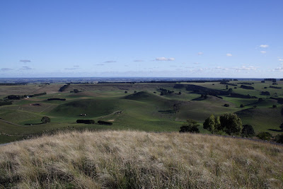
Like the lakes, Mt Leura was a large Maar volcano that blew itself apart about 30,000 years ago. Not content to leave it at that it began rebuilding itself in a series of eruptions which built multiple secondary cones inside the crater.
 The above piccie was taken from the top of the highest cone (which is Mt Leura proper). Each of the humps in the piccie is a small secondary cone. The ridgeline in the middle distance is the rim of the original crater. As you can see if you look closely, the crater is so big there are a number of houses and farms contained within.
 This second photo is of Mount Sugarloaf which is the second largest cone in the crater (again the ridgeline in the middle distance is the crater wall). The lines cut across the cone are a road that spirals up to the top of the volcano.
As Uncle Harry would say that is enough about Camperdown for one night.
From Camperdown we went on to Warrnambool where we stayed the night.
The next morning we went out on the first of a series of day trips along the coast to the west.
After an abortive attempt at photographing the dawn we drove to Port Fairy.
I’ve included this piccie because of the amazing colours.
 These black boulders are the remains of a basalt lava flow.
  The sky and the sea were almost equally vivid blue and the orange colour that “paints” the boulders is naturally occurring lichen that grows along a great deal of this coastline.
The Bay at Port Fairy. Despite the beautiful weather and the holidays the beach was almost deserted.
 The Port Fairy Lighthouse taken across the bay.
 Behind the sand dunes east of the town are a series of lagoons which waterfowl love.
 The black dots on the other side are:
 Australian black swans.
Unfortunately none were cooperative enough for me to get a close up.
Now because no one has yet guessed what my mystery object is (and because I have sadistic tendencies), another photo: this time from the top.
 Maybe I am too much like Uncle Harry for your good!


