So I’ve decided to talk about the fort in two separate posts. Here tonight is the first part about ‘The Rip’ which is the channel that Fort Queenscliff once guarded.
 This first piccie is taken from the fort looking across the narrow mouth of the bay to the Mornington Peninsula near Portsea.
The Rip with a container ship passing.
 As you can see the channel is quite narrow, only about 3 km (1.8 miles across) and in fact the navigable width for a ship of this size is only 250 metres or so.
Given that the bay has a surface area of 1900 square kilometres that means there is always a powerful tidal current running in or out, hence ‘The Rip’. The current going either way is usually around 6 knots.
To add to this difficulty the ships have to change course part way through. To assist with navigation of the passage not one, but two light houses stand in the grounds of Fort Queenscliff.
The Black Lighthouse,
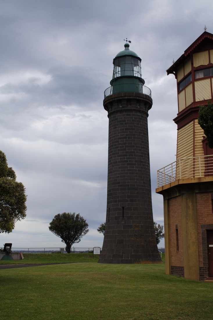 This is one of a handful of black lighthouses in the world. Most are painted bright colours (usually white) to help warn ships off rocks. Unusually this light house was not built to warn ships away from nearby rocks. More about that in a minute
(The wooden tower in the above piccie is not a light house. It is a signal tower from the early days of the fort.)
Interestingly most light houses in the British Empire at this period (the late 1800s) were built to a common plan. This produced a strange feature on the Black Lighthouse.
 The original door was built about 20 feet above ground level. This was because the design was also used on rocks that were covered by high tides. The Government architect was so rigid that this lighthouse had the same door although it is hundreds of metres from the sea and at the top of a high cliff.
Apparently the lighthouse keepers had to climb a ladder to get to the door until nearly 50 years had passed and the door was finally shifted to ground level!
The second lighthouse in the fort is the White Lighthouse.
 Because the fort is still a military establishment I wasn’t allowed closer to the White Lighthouse.
This Lighthouse a few miles away at Point Lonsdale is almost identical.
 So why are there two light houses in the fort one black and one white?
Any guesses?
Well to demonstrate the answer the question I drove a couple of kilometres (1.5 miles) north to the Queenscliff Harbour. At the harbour is this new space age looking viewing tower.
 Up there are some beautiful views: of the Marina
 And of The Rip.
 In the foreground is the boat house that once housed the lifeboat that saved people from countless wrecks in The Rip.
Fort Queenscliff stands on the cliff on the right side of the piccie.
Now if I zoom in (please excuse the poor quality the piccie was taken through salt encrusted glass) you can just about see what the two light houses are used for.
The Black Lighthouse is closer and you can just see the top of the White Lighthouse over the trees.
 Now you can’t quite see (because we are off to one side) the cargo ship in the distance is being lined up with both white and black lighthouses. The Pilot knows that if the ship is travelling on an imaginary line that passes through both lighthouses it is aiming for the deep channel.
The incoming ships are then turned hard to their starboard (their right, to the left side of this piccie) when they get to about where the smaller boat is to follow the channel as it curves around in to the bay.
So these are friendly light houses that say “come here” rather than the usual standoffish loner light houses that are found around most coasts.